


Specialized software for extracting qualitative data from aerial and satellite images and automating geospatial data analyses. The possibilities are endless.
GEOSYSTEMS Polska has been operating continuously since 1995, making a key contribution to the development of geoinformatics in Poland.
Our competences include broadly understood geomatics and spatial information: technologies for its acquisition, processing, analysis and presentation. We perform research and development work and provide services in the field of remote sensing, photogrammetry and GIS geographic information systems.
We are a distributor of specialized software designed to analyze image data Trimble eCognition®. We cooperate with suppliers of satellite image data, both optical and radar.
We implement projects involving the use of unmanned aerial vehicles (UAVs) for image monitoring. We also develop geographic web applications.
We implement scientific and research projects
For years we have been participating in scientific and research projects conducted both by Polish institutions and scientific and industrial consortiums, as well as in international projects. Our areas of research interest are:
- environmental protection
- crisis management
- spatial planning
- geomarketing
- agriculture
- tourism
We create GIS databases
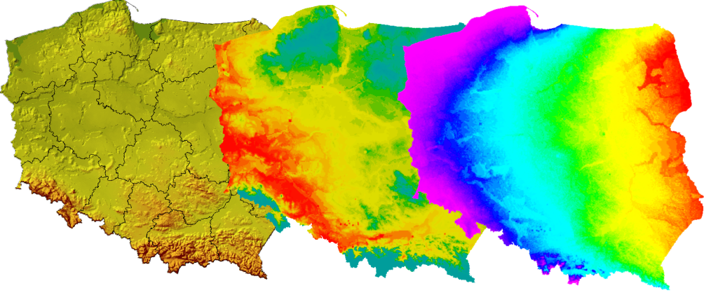
We are developing geographical databases natural resources, infrastructure and land use. We have digital terrain models for the entire country, as well as databases of building heights in urban areas.
Geoinformatics is spatial analysis
Visibility, propagation, proximity and other GIS analyses. Long-term analyzes of changes in the terrain, its form, cover and use. Searching for locations for business and services.
Udostępniamy nasze archiwa na licencji CC-BY (wkrótce).
We provide satellite imagery and processing technologies
We provide image data from various operators, and we are also a distributor and technological partner of leading producers of geoinformatics software intended for the processing and analysis of image data: ERDAS®, HEXAGON®, Trimble® eCognition.

An innovative online application for finding tourist destinations in Europe and trip planning
In cooperation with scientific institutes, universities, administration and other companies, we are looking for new applications of spatial information, observations and satellite positioning. We also try to promote techniques for their use.
We invite all companies and institutions interested in implementing geoinformatics technologies to cooperate with us!
Latest news:
New identity of our company
Faced with the challenges of the modern world of geoinformatics, it is time for us to take a closer look at the past, boldly look into the future and take a step towards a new…
Winter promo
We invite you to participate in a promotional campaign addressed to existing and new users of Trimble eCognition® software. The promotional campaign also covers some of our archival geoinformatic resources. High-quality GIS data for the…
Imaging aerostat – final operational tests
May 23 this year at the IUNG-PIB Agricultural Experimental Station in Grabów nad Wisłą, a team composed of specialists from GEOSYSTEMS Polska, IPPT PAN, Adaptronica Sp. z o. o., Drony.pl conducted operational tests of a…